Towards a resilient and sustainable Medierranean
The Mediterranean is warming 20% faster than the global average. Sea levels are rising. Extreme weather events are intensifying. Yet most coastal municipalities still operate without an integrated management plan.
The window to act is narrowing. The damage already visible – eroding beaches, flooded historic towns, collapsing fisheries – is only the beginning. Without integrated coastal planning, it will accelerate.
But there is a tested, legally grounded path forward. The Barcelona Convention gives you the mandate. This toolkit gives you the method. Your coast needs a plan. This is how you build one.
faster warming than global average
total Mediterranean coastline under pressure
of Mediterranean population living in coastal areas
horizon for current coastal planning decisions

This guidance applies to the process of coastal planning in the Mediterranean.
Coastal planning is a continuous process: a structured framework for translating long-term sustainability objectives into near-term decisions, anticipating change and prioritising actions. Coastal planning aligns spatial choices and risk management to reduce future exposure and avoid irreversible development lock-ins. Within that continuous process, a coastal plan is a waypoint, capturing where the community stands, what it has agreed, and the direction it has chosen. The coastal plan is just a milestone on the journey towards a resilient and sustainable future for your coast and its communities.
Coastal planning takes many forms, and at national, regional and local levels:
This Tool Kit: builds on established legal commitments and decades of Mediterranean practice in coastal planning and management.
You are not acting alone or without authority. Every Mediterranean country has signed the
Barcelona Convention and its ICZM Protocol – giving you a legally binding framework that national and local officials can invoke, cite, and use as leverage.

The ICZM Protocol for the Mediterranean uniquely defines the coastal zone in spatial terms, emphasising the interdependence of the land and coastal waters. Article 3 of the ICZM Protocol defines the geographical boundary as:
“The seaward limit of the coastal zone shall be the external limit of the territorial sea; and the landward limit shall be the limit of the competent coastal units.”
The maximum seaward limit is the external limit of the territorial sea – relatively straightforward, and unlikely to need reduction.
The landward limit is less straightforward. The type and nature of “competent” coastal units varies greatly around the Mediterranean – in geographical scale (from small municipalities to extensive counties and regions) and in their functions, competencies and capacities. The common identifying element is that all border the sea.
The ICZM plan boundary should conform to or fall within these Protocol limits. The geographical scale cannot be predefined – one or more of the following should determine it:
National guidance or allocation of responsibilities to individual administrations, regions or municipalities
Bottom-up initiatives from individual or groups of coastal administrations
Physical nature of the area and its landscape
Local and traditional perceptions of the coastal area or its issues
Functional areas sharing common infrastructure, transport and access
The marine area should always be included
Rate your situation honestly across six dimensions. Drag each slider from red (not in place) to green (fully established). Your coast faces real challenges – but resilient coastal planning starts here. Begin with Step 1: build a mandate, name a lead, and start the conversation. Momentum is everything.
Ne postoji mandat ni uspostavljen proces.
Nijedan tim nije imenovan
Ne postoji osiguran proračun
Aktivno protivljenje ili potpuni izostanak kontakta
Postoji vrlo malo ili nimalo relevantnih podataka
Ne postoji nikakva pravna osnova
Lorem ipsum dolor sit amet, consectetur adipiscing elit. Ut et massa mi. Aliquam in hendrerit urna.

“Fools rush in where angels fear to tread”
- Alexander Pope, 1711
Establish political commitment, identify your lead agency, form a core team, and draft terms of reference. Secure even a small budget to demonstrate seriousness. Map existing policies and stakeholders who must be involved from day one.

““The future depends on what you do today””
- Mahatma Gandhi
The overall aim of the Map the Present and the Future step is to add substance to the issues and aspirations initially identified in the preceding step – making the invisible visible and engaging stakeholders in the search for outcomes.

“"We are limited, not by our abilities, but by our vision."”
- Khalil Gibran
A central purpose of coastal planning is to translate the ICZM Protocol’s overarching vision into shared, place-based aspirations that can be expressed through tangible actions and deliver practical, sustainable outcomes.

“"The greatest danger is not that our aim is too high and we miss it, but that it is too low and we reach it." ”
- Various attributions
The ambition here is to develop a living Coastal Plan, a plan that is flexible and regularly updated, a plan that adapts to new information, changing environmental conditions, and community needs, rather than remaining fixed. In short, it’s a dynamic plan that evolves over time and with the community it serves. Your living Coastal Plan should be locally grounded, participatory, and adaptable - your living Coastal Plan becomes effective when it is created with people, not for them.

“"Action without vision is only passing time, vision without action is merely daydreaming, but vision with action can change the world.” ”
- Nelson Mandela
This is the culmination of the coastal planning process. This is the point at which the partners in the planning process move from agreement of the measures to be included the Action Plan to prioritising, resourcing, and implementing concrete actions. Sustainable development as business as usual The ultimate goal of your Action Plan is to move from a push model - where progress depends on continuous driving, coordination, and pressure from your Coastal Plan proponents - to a pull model, where the process is naturally taken up and sustained by the coastal society itself. At this point, sustainable development becomes “business as usual” - embedded in everyday systems, resilient to change, and no longer dependent on exceptional leadership or external stimulus.

Obtain a formal political commitment if not already in place: ministerial decree, council resolution, or adopted strategy. Name the lead body and assign responsibilities.

Identify who has ultimate legal and financial responsibility for the coastal planning process. Ensure the body has appropriate capacity, resources, flexibility, and institutional patience.

The ICZM Protocol for the Mediterranean uniquely defines the coastal zone in spatial terms, emphasising the interdependence of the land and coastal waters.

Identify funding sources for coastal planning. Identify potential financing sources and institutional arrangements to implement future actions.

Agree and set up the Steering Committee. Other bodies may include an Advisory Body, and consultative group(s); agree their purpose and remit, reporting structure meeting frequency, and accountability.

Assemble an inter-departmental team (typically 3-8 people) with appropriate environmental, planning, legal, community and finance expertise. Set Terms of Reference.

Produce the roadmap for the planning process: geographic scope, vision, governance structure, staffing, funding sources, timeline, and risk analysis.

Agree and sign a formal statement of shared purpose among core partners: a Mission Statement, MoU, or equivalent. Obtain sign-off.

Map the likely range of human and natural forces, existing sectoral policies, and their potential interrelationships. This is your prospectus for the coastal planning.

Establish branding and identity, identify your community and stakeholders, appoint moderators, and set measurable engagement targets.

Identify all those who manage, influence, use, or depend on the coastal zone. Share the preliminary stakeholder list for validation before invitations are sent.
Map risk areas (erosion, flooding, fires, salinisation), climate projections, sensitive ecosystems, exposed urban areas, and socio-economic dynamics. Use best available data - not perfect data.
Identify the natural and human-induced processes crossing the land–sea boundary. Apply the tested 14-step LSI approach from the PAP/RAC Marine Spatial Planning Platform.
Document recent events, local perceptions of risk, traditional knowledge, and the social, economic, and cultural dynamics of the coastal community. Include gender and social vulnerability analysis.
Use the Climagine participatory methodology to generate "what if?" visions of the future with stakeholders.
Evaluate how remote sensing, GIS, and AI tools can support monitoring of shoreline change, erosion, ecosystems, and human activity - while recognising their limitations.
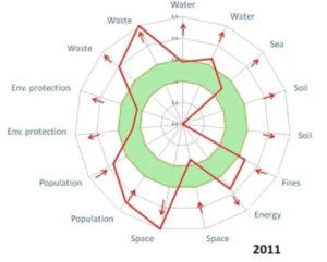
Select SMART sustainability indicators (Specific, Measurable, Achievable, Realistic, Time-bound) for each sustainability dimension.
Synthesise CVA, LSI analysis, community knowledge, and scenario work into a coherent evidence base that is fit for purpose and accessible to a non-specialist audience .The analysis should clearly outline the current state and future trends Complete the indicator framework..
Run participatory workshops using the Climagine methodology. Engage diverse stakeholders; communities, sectors, neighbouring authorities - in a structured process of shared diagnosis.
Co-create a single long-term Vision Statement (20–30 year horizon) that is both rational and inventive: rooted in what is known, shaped by what is wanted, and bounded by what is possible.
Your living Coastal Plan will consist of a unique range of measures tailored to the needs of your Coastal Plan area - its environment, its economy, its society and culture. The measures in a Coastal Plan can be grouped into three types: Societal, Blue-Green, and Grey/Hybrid which, together provide an integrated framework to improve climate resilience and sustainable development for the coastal zones of the Mediterranean. The three categories are divided into three separate Tasks below; Tasks 1a, 1b, 1c.
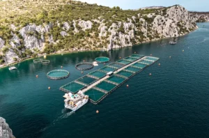
Identify ecosystem-based measures: wetland and dune protection, Posidonia seagrass restoration, marine protected areas, river and floodplain restoration, urban green infrastructure, and sustainable agriculture.
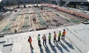
Where nature-based solutions are insufficient, identify hard engineering options: seawalls, groynes, beach nourishment, storm surge barriers. Design hybrid solutions combining grey and blue-green approaches.
Identify funding sources (EU Cohesion Funds, GEF, Green Climate Fund, INTERREG MED, national budgets, private finance). Design co-financing and blended finance mechanisms.
Allow time and resources to achieve political approval. Use the approval process as an opportunity to elevate the plan's status; public launch events, ministerial forewords, and formal adoption statements build institutional commitment.
Redesign governance arrangements for implementation. Delivery governance differs from plan preparation. Embed coastal planning firmly in local institutional and social structures, designed for the long term.
The goal here is to ensure that time, money, and human capital are directed toward effective, feasible, and equitable delivery of the measures in the coastal plan. The key message here is that effective implementation depends on simple, transparent prioritisation of outcomes.
The Action Plan should be a living document, kept under regular (annual) review to reflect uncertain and changing conditions. Typically, the Action Plan will look forward over a 5–10-year period and beyond for implementation, but with an indicative schedule of individual actions extending to 20-25 years.
Measuring and monitoring your progress is essential to ensure that coastal planning moves from vision to effective action and - most importantly - results. Conventional approaches describe indicators and milestones as measures of progress in the delivery of coastal plans. However, in an uncertain world and the changing conditions, it is necessary to mark moments - tipping or trigger points - when an existing policy, measure, or pathway can no longer meet agreed objectives
Launch small-scale, strategic demonstration projects to build confidence and credibility. Pilots need not be the most important actions - they should be visible, achievable, and supported by local stakeholders.
Maintain transparency through public reporting. Share results - including what has not worked. Transparency builds trust and sustains political support across electoral cycles.
Conduct formal plan reviews every 5–10 years, or earlier if tipping or trigger points are reached. Adapt priorities, governance, and measures in response to changing conditions and new evidence.
Statutory basis – where relevant, the national law, governing body resolutions or strategic mandate under which the plan is prepared (ex. The Coastal Law No. 81-12 in Morocco)
The broader regional legal context, notably in the Mediterranean the implementation of the ICZM Protocol, and other relevant regional drivers such as the EU MSP Directive.
The international legal context, in particular the United Nations Framework Convention on Climate Change, 1992, Article 4.
The international, regional or local programme(s) under which the plan is being prepared.
Non-statutory basis – coastal planning may be a non-statutory plan, policy, programme or action that is not legally required by law but is developed to guide decisions, coordinate stakeholders, or provide strategic direction.
Non-statutory plans are advisory, take-up is voluntary, and they rely on consensus. best practice and a strong evidence base.
Although lacking the force of law, they can fill gaps between the formal regulations of spatial plans – allowing flexibility, innovation, and stakeholder input. They can cross administrative boundaries, notably in the Mediterranean linking land and sea. High-level political sign-off lends authority and legitimacy to a non-statutory plan, signalling clear political commitment and institutional backing. It encourages uptake by agencies and stakeholders, supports alignment with existing policies and funding decisions, and increases accountability, even without legal force.
Who is the lead – who has the ultimate legal and financial responsibility? A deceptively simple question, but the lead body has very important responsibilities including financial and staff management, reporting and legal accountability. It is vitally important that this role is handled by a body with the appropriate capacity, flexibility, and institutional patience.
Coastal planning requires and level of institutional capacity and purpose corresponding to the scope and ambition of the Plan – it is likely that the process may be based on a partnership, such as local and regional authorities, academic institutions, NGOs, or external agencies. Whatever the mix, roles and responsibilities must be absolutely clear.
Who is the host – where will the planning staff be based, who will employ them and who will they report to?
Article 3 of the ICZM Protocol defines the geographical boundary of the coastal zone as follows:
Exceptions to this are defined where:
The maximum seaward limit is, therefore, relatively straightforward – the external limit of the territorial sea. There is unlikely to be a strong reason for reducing this maximum.
The landward limit is, however, less straightforward – the type and nature of “competent” coastal units varies greatly around the Mediterranean in terms of both their geographical scale (from small municipalities to extensive counties and regions), and in terms of their functions, competencies and capacities. One common element identifying the “competent” units is that all of them are bordering the sea.
Geographical Scale The geographical scale of the area cannot be predefined in this guide, and one or more of the following should determine it:
National guidance or the allocations of responsibilities to individual administrations, or to levels of administration such as coastal regions, counties or municipalities.
Bottom-up initiatives from individual or groups of coastal administrations.
The physical nature of the area and its landscape.
Local and traditional perceptions of the coastal area or its issues.
Functional areas that share common infrastructure, transport and access.
The marine area should always be included
Plan preparation process should take place with a reasonable degree of financial certainty.
The majority of planning projects and programmes have relied on time-limited, external grant funding from national and transnational bodies (typically 3- or 5-years duration). Without such funding valuable experience and lessons, and good practice would not have developed. However, such time-limited funding can lead to a ‘cliff-edge’ scenario at the end of the eligible period, and early planning is required to maintain momentum beyond this period. More detail of financing and sources is set out in Steps 4 & 5.
The Steering Committee is responsible for guiding and overall decision-making to oversee progress, and provide strategic direction, along with resource allocation, reporting, and evaluation. The Steering Committee should function – it is simply not enough to have a structure and names on paper – the Steering Committee should have the administrative infrastructure and a secretariat to enable it to hold regular meetings, be accountable and to take and implement decisions.
Membership of this core Steering Committee should be based on partners’ abilities to contribute funds, staff time or technical support, not only to attend meetings.
The Steering Committee should be established with clear terms of reference, co-chairs, explicitly chosen for geographic, gender and technical balance. Typically, such an effective group would consist of 10 to 15 committed core members. This structure means the core group can act decisively, but can be supported by a wider Consultation Group for input and legitimacy.
Importantly, while the membership should be both representative of those organisations with a decisive decision-making role, it should also be proportionate to the scale and nature of the area and the resources available to support it.
Statutory actors may include:
Non-statutory actors may include:
The challenge is to design a governance body that is of a size to operate efficiently, yet encompassing all those with a legitimate interest in the governance of the area.
The Steering Committee operates through regular, time-bound meetings aligned with key steps in your coastal planning. Meetings focus on clear agendas, concise briefing notes, and defined decisions rather than technical detail. Decisions are normally taken by consensus, with formal voting used only where necessary. The Steering Committee validates outputs at agreed milestones, resolves conflicts between sectors, and provides direction between meetings through a small chairing team or secretariat. Clear records of decisions and actions ensure continuity, accountability, and followup.
The Steering Committee is accountable for guiding the process, validating key outputs, and ensuring your coastal planning reflects agreed priorities. Accountability is maintained through transparent decision-making, documented resolutions, regular reporting to the responsible authority, and clear links between Steering Committee decisions and subsequent implementation actions.
Here’s a quick check list to consider when setting up your Steering Committee
Who are the coastal planners? Are they ‘in-house’ existing staff? If so, do they have the appropriate skills-set and experience? Or will additional experts be brought in? If so, will they be directly employed and on what terms, or will consultants be employed? Or will the reality be a combination of these options? In all cases the lines of management and reporting must be very clear.
Potential Inception Report template:
Agreed and signed among the core partners in the coastal planning process to help establish the collective purpose. Such an agreement may be variously titled as a Mission Statement, Mandate, Contract, Memorandum of Understanding (MoU), or other appropriate title.
The agreement should be concise and clear – consisting of clear, unambiguous statements, diagrams and maps to which partners can sign-up to.
Once this document is agreed, obtain sign off by the relevant sponsoring bodies.
Scoping Report – the baseline snapshot
The purpose is to map the likely range of human and natural forces, the existing sectoral policies, and their potential interrelationships to be used as a trigger for the process and a focus for discussion, full analysis and identification of priorities in subsequent steps – this is the Scoping Report. Think of this also as a prospectus for the plan. The analysis in the Scoping Report is not the same as the fuller issue and more detailed analysis that will follow in later steps.
A Scoping Report should contain the preliminary assessment of the problems, a snapshot of the issues, drivers, pressures and risks along with their relative importance, policy context, and interrelationships. Typically prepared by experts, but workshops can be valuable to raise issues from stakeholders.
Preliminary Assessment – questions it may begin to answer
Communication and Engagement Strategy
Purpose
Contents
Communication and promotion mix – how the message is conveyed. This will include press and TV, online, print, events and conferences. Internally this will include meetings, printed and electronic media. Training in communication may be required. Innovative methods of communication and visualisation should be considered.
Participation
The Ladder of Participation below has been used to identify and increase the amount of citizen power in decision-making processes. It serves to evaluate whether engagement is meaningful or simply a “window-dressing” exercise that maintains the status quo. The objective therefore is to seek to move well beyond the simple “inform” level towards the “Co-create”.
Coastal Vulnerability Assessment (CVA) – the process of making climate change at the coast visible, identifying both who and what is at risk from climate impacts, and why – so that adaptation actions can be targeted most effectively. A form of Climate Change Vulnerability Assessment (CCVA) is essential to the setting of priorities to improve climate resilience. Mapping will be an essential tool to:
Your coastal planning will include the analysis of the interactions of natural and human processes between land and sea – Land Sea Interactions (LSI).
One of the key differentiators of coastal planning over conventional terrestrial and marine spatial plans, therefore, is the ability to consider the interactions of uses and activities across the boundary between land and sea – the impacts from sea to land and from land to sea of activities – LSI.
In the Mediterranean region, compound flooding – the simultaneous effect of multiple flood drivers – demonstrates how interconnected land and sea processes are. The drivers of compound flooding, including storm surges, rainfall extremes, sea-level rise, and river discharge, all cross the land-sea boundary. The Mediterranean is particularly vulnerable to this form of flooding because of its unique combination of geographic, climatic, and socio-economic factors. Narrow, low-lying, heavily urbanised coastal plains have little space for water to drain or for natural buffers. Intense, short-lived storms bring torrential rainfall and strong winds. Short river catchments respond rapidly to these storms as storm surges severely inundate coastal land. Rising sea levels amplify flood risk. Managing these drivers separately will fail to mitigate or prevent flooding.
Land-based measures such as urban drainage systems, river embankments, and land-use regulation cannot work properly if they ignore what’s happening at sea. Conversely, sea-based measures such as coastal defences, port design, or ecosystem protection are incomplete if they ignore river and rainfall inputs. Their interactions define both the climate risks and the sustainable solutions.
Under the ICZM Protocol, the consideration of LSI is mandated through the definitions of the coastal zone (Figure XX) and ICZM as involving interlinked land-marine ecosystems and human activities. The ICZM Protocol articulates objectives such as preserving coastal ecosystems, preventing natural hazards like erosion and flooding, and applying the ecosystem approach – all inherently involving LSI.
LSI involve both natural processes (e.g., sediment transport, coastal erosion) and human-induced socio-economic activities (e.g., agriculture runoff, infrastructure) crossing the land–sea interface. A more detailed description of LSIs offering a detailed 14-step approach to guide planners, based on tested Mediterranean pilot cases can be found on PAP/RAC’s Marine Spatial Planning Platform.
Recognise recent events or experiences, and the lived experience of the local community -particularly climate change events such as flooding, severe heat, etc., or the adverse impacts of tourism on society and the environment. Where communities struggle for basic needs for example, their capacity to engage with plans to adapt to long-term climate hazards, or to restrict further development may be severely compromised.
Break down silos, build trust, and bring professionals and academics together across geographic and institutional boundaries. Ensure that assessments are unique and customised to the community, including gender, ethnic group, and other relevant cultural or socio-economic identities.
In assessing resilience to climate change in particular, quantitative analysis of risk and exposure are not the same as the assessment of vulnerability which requires a real understanding of practical, real-world factors. Examples of this are legion, from the differing cultural or generational interpretations of threat to misleading or inadequate assessments of the condition of protective infrastructure against floods.
Scenarios are ‘what if?’ visions of the future, and mapping possible futures is the bridge between the early steps of coastal planning – mapping the present – and the foresight to underpin a resilient and sustainable future.
Participatory methodologies such as Climagine combine collective visioning, action planning, and indicator development within a single, scenario-making process. – and the process of generating them through a participative process is a key part of coastal planning.
Climagine systematically integrates local knowledge, increases awareness and develops solutions through broad partnerships. In this way, coastal planning is co-created by all relevant authorities and stakeholders.
Engaged stakeholders become owners of the coastal plan and, consequently, key actors in its implementation.
More specifically, scenarios are used to:
AI and remote sensing can help turn uncertainty into actionable insight, enabling Coatsl planning to be flexible, proactive, and resilient.
Remote sensing provides high-resolution, near-real-time monitoring of shoreline change, erosion, ecosystems, and human activity.
AI may assist in analysing climate, ocean, and other data to forecast risks, identify vulnerable areas, test future scenarios, and support rapid hazard detection and response. Visualisations and predictive maps also make complex information accessible to communities.
In the Mediterranean, remote sensing, GIS, and geomatics are now essential for analysing climate-driven change, including land use, coastline dynamics, floods, urban expansion, lagoons, and marine processes. Satellite imagery supports the monitoring of erosion-prone coasts, fragile lagoon ecosystems, marine traffic, pollution, storms, and habitats such as Posidonia meadows, with AI increasingly automating analysis and mapping.
Three caveats apply:
With the above cautions in mind, these are the vital areas of work to underpin the development of your Coatsl planning in the Mediterranean
Sustainability Indicators may identified jointly by the experts and stakeholders. These indicators should provide a better understanding of the evolution of sustainability and associated challenges. Selected indicators need to be SMART — meaning Specific, Measurable, Achievable, Realistic, and Time-bound.
Indicators to measure plan success will track both the coastal planning process and its outcomes. These will be refined in later steps, and form the basis of the monitoring framework in Step 5.
Achieving consensus using the Climagine participatory methodology.
Bring experts and stakeholders together in a workshop setting to agree on the vision and explore the future of your coastal zone, using scenarios that highlight the impacts of the changing climate, trends in coastal issues and conflicts associated with the use of natural resources.
In this step, a sustainable numerical range, known as the Band of Equilibrium, needs to be defined for all selected indicators. This will enable the description of the current state and the (un)sustainable trajectory of the dimensions it represents. The obtained data will be presented in the Climagine amoeba diagram (see below). Among the key conditions for the success of the method is the availability of data needed for developing an amoeba diagram. Otherwise, different participatory methods need to be proposed. (Example taken from the Coastal Plan for Šibenik-Knin County, Croatia, 2015).
The amoeba diagram is produced to show all indicators simultaneously, using points that indicate their known values. The green area represents the band of equilibrium. After this, creating an amoeba diagram of a past situation can be used to show changing trends. Scenarios can be developed starting from the two amoeba diagrams and a third amoeba diagram can be produced with projections by players concerning the future of their territory. Finally, all three diagrams can be combined into a single image.
Adapted from the Plan Bleu Policy Notes #37

A single Vision Statement includes priorities and objectives, along with supporting interpretive material and reports of the participation process. It can be considered as a visionary interpretation of the Objectives of ICZM (Article 5 of the ICZM Protocol).
A vision must be both rational and inventive – this is foresight. Such foresight thus lies at the intersection of three dimensions:
Foresight differs from forecasting in two ways. Firstly, it is as interested in uncertainties as certainties. Secondly, it focuses as much on what is going to happen (exploratory foresight) as on what one might want or not want to happen (normative foresight).” – The Mediterranean by 2050 (Plan Bleu 2025)
Applied to the coast, foresight allows a plurality of potential futures. The coastline is not a fixed space, but a territory to be explored, anticipated, and collectively shaped with all relevant stakeholders.
In a rapidly changing world, characterized by accelerating changes, unstable contexts, multiple influences, diverse and sometimes contradictory expertise, and interdependent actors, this “plurality of potential futures” means there are many possible ways the coast could change – just like in quantum physics, where different outcomes are possible at the same time.
What actually happens depends on the choices people make today: how we build, protect nature, prepare for storms, or use the shoreline. Our decisions guide which future becomes real. It relies on the diverse mobilization of field actors, the establishment of a monitoring system, and the adoption of a long-term strategic vision.
Here is the Vision Statement for the Kaštela Bay (Croatia) from the Horizon DesirMED project (2025):
“Kaštela Bay as an urban area adapted to climate change, with clean sea and air, green spaces and restored agro-ecosystems. Efficient infrastructure, public transport and stormwater management ensure a better quality of life. Residents are connected, aware of the value of their space and actively participate in its preservation and development.”
There is no one-size-fits-all; a living Coastal Plan adapts its priorities and actions to specific local conditions rather than relying on generic models. Importantly, in addition to science and data, it builds on the community’s traditional knowledge, daily experience, and sense of place – understanding how people use, protect, and depend on the coast.
The measures are not used in isolation; for example, measures identified under Blue-Green options rely on enabling governance measures listed in the Societal options. No single type of measure is sufficient – effective Coatsl planning require a mix of Societal, Blue-Green, and Grey options tailored to the local environment, society, and institutional capacity. In practice, therefore the majority of measures in the plan will be hybrids of two or more of the Societal, Blue-Green, and Grey options.
Potential measures to be included in a Coastal Plan should thus combine physical protection, adaptation of human activities, and ecosystem conservation, while relying on local and scientific knowledge, stakeholder participation, and a long-term forward-looking vision.
These measures use ecosystems to buffer climate impacts, support biodiversity, and community wellbeing. Blue-Green measures provide multiple co-benefits such as flood reduction, cooling, biodiversity conservation, recreation, and carbon storage. In the Mediterranean, where tourism and ecosystems coexist, these measures align environmental and economic priorities.
The main options may include:
These measures may require space and time to mature, and performance can decline under severe or prolonged stress (e.g., drowning wetlands from sea-level rise, excessive development, tourism pressure). Regular monitoring and maintenance are needed.
Grey measures are primarily designed to protect people and assets from climate hazards where retreat or nature-based solutions are impractical. ‘Hard’ measures such as seawalls or breakwaters are often combined with other urban infrastructure such as esplanades or road or rail corridors. Grey measures deliver immediate, visible protection and are often indispensable in dense, high-value coastal areas. However, they are generally costly, require ongoing maintenance, and can damage coastal ecosystems or shift erosion elsewhere. They may also create “false security” if climate conditions exceed their design thresholds.
Examples:
Grey measures may be combined with blue-green (nature-based) solutions to create sustainable, resilient hybrid solutions, leveraging the strengths of both nature-based and engineered solutions, reducing maintenance costs, and supporting ecosystem services.
Examples that combine blue-green measures with hard, concrete infrastructure for coastal protection include:
The ambition of your Coastal Plan will be tempered by the financial and other resources available to deliver it. Coastal planning differ critically from their land and marine spatial plans counterparts in that the Coastal planning rely primarily on practical implementation rather than regulation – this in turn relies on the resources available for that implementation.
It is not realistic to set out in detail the financial arrangements for the delivery of all the individual measures – this is the task of the Action Plan set out in Step 5 – but the Coastal Plan should set out financial detail at a strategic and indicative level.
The Coastal Plan should indicate:
Your Coastal Plan should also consider local financial management capacity to match its ambition, identifying where necessary the need for capacity development, including:
The realisation of the ambitions of your Coastal Plan depends not only on direct public investment but, as the World Bank (2025) and others point out, Coatsl planning can strengthen investor confidence, help reduce poverty, and promote gender equality. In designing measures.
Coastal planning should therefore apply, where possible, the following principles:
Formal Approval – allow time and resources to achieve political approval of the plan. The engagement and support of stakeholders and the community established through the preparation process will pay dividends at this step. The legal basis of a Coastal Plan will vary according to its administrative context – it may have a firm basis in national law, in which case high-level approval is required.
Alternatively, it may be initiated at a local level and considered a voluntary, non-statutory document. In this latter case, consider the appropriate level of political sign-off to lend your Coastal Plan authority and legitimacy, signalling clear political commitment and institutional backing – even without legal force.
See the political sign-off as an opportunity rather than a chore – an opportunity to elevate a plan’s perceived status as an endorsed statement of strategic intent rather than a purely advisory or bureaucratic necessity. Public launch events, ministerial forewords, and formal adoption statements signal priority and commitment, encouraging agencies to align policies, funding, and decisions with the Coastal Plan. Over time, repeated citation in official strategies and approvals reinforces its perceived authority and weight.
Dissemination – disseminate the plan and its vision widely long after its completion to ensure that it plays a central role in the future sustainable development of the plan area.
Governance arrangements for delivering your Coastal Plan may differ from those for its preparation – delivery needs to be firmly embedded into local institutional and social structures, and designed for the long-term. Effective governance ensures institutions and stakeholders work coherently across land and sea to deliver real measures.
Without integrated, well-resourced governance, even the best-designed coatsl planning risk remaining unimplemented or fragmented, leaving coastal communities vulnerable to climate and development pressures, as well as disillusioned with the process.
Revisit the guidance for setting up a successful Streering Committee set out in Step 1. Moving from Plan to Action it’s time revisit and redesign those governance measures set out at the very beginning of the planning process – the “Prelude” and “Initiate” stages.
Consider:
Just as at the plan preparation stages, the roles and responsibilities must be absolutely clear, these include:
Three simple principles are the keys to the successful engagement of partners’ passions in coastal planning governance:
Connect the plan’s vision and measures to values – embracing culture, community, economy, and environment.
Foster ownership – through genuine participation, visible results, and shared success stories.
Celebrate collaboration – build trust, and show how joint action protects or enhances what people care about most – their coast.
Governance structures range in a spectrum from centralised “top-down” models, remotely dictated from a distant central national or regional government, to devolved “bottom-up”models, locally-managed at a municipal or local county level.
Experience from coastal management around the Mediterranean shows that those structures closest to the locally-managed ‘bottom-up’ model have the most potential to be liberating – connecting, enabling, evolving, and adaptive, being:
Be smart – Mediterranean ICZM experience shows that Coatsl planning is most effective when treated as living agreements – periodically adjusting priorities in response to climate risk, socio-economic change, and shared learning. As the IPCC put it, “Adaptation is an iterative process of learning, adjustment, and response to change” or, most simply, “When the facts change, I change my mind. What do you do?” (attributed to John Maynard Keynes).
Firstly, consider the following critera for each measure when deciding the Plan’s short-list of measures:
Secondly, adopt a simple, widely understood set of priority classes. Asign each measure to one pf the following:
Urgent actions override normal sequencing and are activated by clear, existential triggers rather than planning cycles. Once stabilised, urgent actions should be reviewed and either scaled, adapted, or incorporated into Medium or High priority measures.
High Priority actions signal measures that are critical to achieving agreed objectives, address immediate or escalating risks, and are feasible within existing capacities. High priority actions typically address immediate or foreseeable risks or needs, and are implemented without waiting for further signals. High-priority actions help delay or avoid approaching crisis triggers or tipping points. Given their value in building support for the delivery of your coastal plan, potential pilot projects (see Task 3 below) could also be considered as a High Priority.
Medium Priority actions may depend on additional resources, enabling conditions, or further learning. Additionally, they may be linked to defined trigger points. Triggers may include thresholds in flood frequency, erosion rates, ecosystem condition, socio-economic vulnerability, or policy changes. Medium-priority actions therefore remain “on the shelf” but ready for activation when monitoring indicators signal that conditions are shifting.
Low Priority actions remain valid, but are deferred due to lower urgency, higher uncertainty, or limited current capacity.
Phasing is all about “when” – the timeline and target for the actions. This is a roadmap to initiate the actions to implement the measures in the coastal plan – providing a sound institutional and operating foundation. At the bottom of this box
is a link to a downloadable Roadmap template
Climate change adaptation measures in particular will need continuous review in part due to the uncertainties in projected warming and the range of potential impacts (e.g. sea-level rise, storminess, and flooding). Decisions in adaptation, therefore, need to take place with recognition of uncertainties over long timescales (i.e. 50 years plus). Making robust near-term decisions is therefore crucial – balancing the urgent needs of today while keeping options open to adapt in the more distant future.
Due to these shifting hazards we need pathways that will accommodate the unavoidable reality of climate change – a planning framework that organises actions over time under uncertainty; maps adaptation pathways, identifies tipping or trigger points, and allows switching strategies as conditions change, ensuring long-term, flexible, low-regret decisions.
Most importantly, your Action Plan should be designed to change course before risks become unmanageable – designed to act early, adjust priorities, and avoid crisis decisions.
Download an Action Plan example and Word template here:
Action Plan example (pdf)
Action Plan template (MS Word)
A more sophisticated methodology, the “Dynamic Adaptive Policy Pathways” (DAPP) provides a a structured planning approach for decision-making under deep uncertainty in climate and water management, producing metro-style pathway maps to visually show how policy choices can evolve over time, making complex, uncertain futures intuitive. It is however limited in its application to complex, multi-themed coatsl planning.
These are the three foundations stones of progress measuring and monitoring:
Indicators track progress and detect change.
Tipping or trigger points activate pathway change
Milestones translate objectives of your coastal plan into observable points of progress.
Indicators have twin purposes: tracking both progress in general and warning of declining performance:
Socio-economic tipping points such as repeated disruption to communities or local authorities to the point where they no longer accept repeated damage, emergency repairs, or unequal protection outcomes and the loss of trust in the voluntary Coatsl planning approach.
Tipping or trigger points – activate pathway change – providing a basis for adaptive coastal governance under uncertainty, the point where carrying on as planned no longer works – the risks, costs, or impacts have changed enough that the action – and even the coastal plan itself – needs a rethink, not just a minor tweak.
Milestones translate your objectives into observable points of progress. Milestones track progress in governance, coordination, knowledge development, spatial planning, ecosystem management, and socio-economic action.
In practical terms, a balance needs to be struck between milestones being frequent enough to support learning and adjustment, but not so frequent that it becomes burdensome or impractical. A suggested structure:
Frequency: Annual (or continuous monitoring with annual review)
Purpose:
Examples:
Frequency: Every 3–5 years
Purpose:
Examples:
Frequency: Linked to tipping points or scenario thresholds, rather than fixed dates
Purpose:
Examples:
Download an overview of the monitoring and a review cycle here:
Monitoring, milestones and a review cycle for a Coastal Plan (pdf)
Pilot actions – building confidence and credibility
Pilot (or demonstration) actions play a crucial role in building support for the effective delivery of coastal planning – they turn the abstract of your coastal plan into tangible, real-world experiences. Primarily, they build confidence and credibility among the partners (and funders) and the public.
Pilot actions need not be the most important or urgent, rather they are likely to be small-scale, strategic initiatives that demonstrate quick solutions to recognised problems or issues. With pilots, small may be beautiful – small enough to control, large enough to be meaningful. Pilots should be supported by local stakeholders to ensure ownership and success. To the experts they may seem to be of marginal importance, but to the local community – and the sceptics in particular – they demonstrate that things can change as a result of the Plan.
Whilst their short-term impact may be limited, their cumulative, long-term impact in terms of building trust and credibility can be enormous. Pilot actions have multiple benefits, including:
Demonstrate Feasibility and Impact
Pilot actions show that the proposed measures work in real conditions
Build Trust and Local Ownership – when communities are involved in designing and implementing pilot actions, they become co-owners of the process.
Learning Laboratories – turning learning into practice
Attract Funding and Partnerships
Funders and policymakers prefer to invest in initiatives with visible results.
Foster Cross-Sector Collaboration
Pilot projects often require cooperation between multiple institutions – local governments, ministries, NGOs, and private actors.
Communicate Change Effectively
Pilots make adaptation visible and relatable.
Storytelling – pilots provide visible examples to engage the public and media, encouraging political support.